Airport Line
Airport Line uses Vektor.io to manage design data and support stakeholder communication
11.5.2026
Lentorata (Helsinki Airport Line) is one of Finland’s most demanding rail infrastructure projects. Currently in the planning phase, the approximately 25-kilometer rail connection will enable direct long-distance train services to Helsinki Airport while improving rail capacity across the Finnish rail network. Running almost entirely in tunnel, the project generates large volumes of design data and requires continuous coordination, information management, and collaboration between multiple disciplines and stakeholders.
According to Siru Koski, Design Director at Lentorata Ltd, the key challenge in a large and long-term project goes beyond technical solutions and includes managing extensive and continuously evolving data as well as communicating plans to different stakeholders.
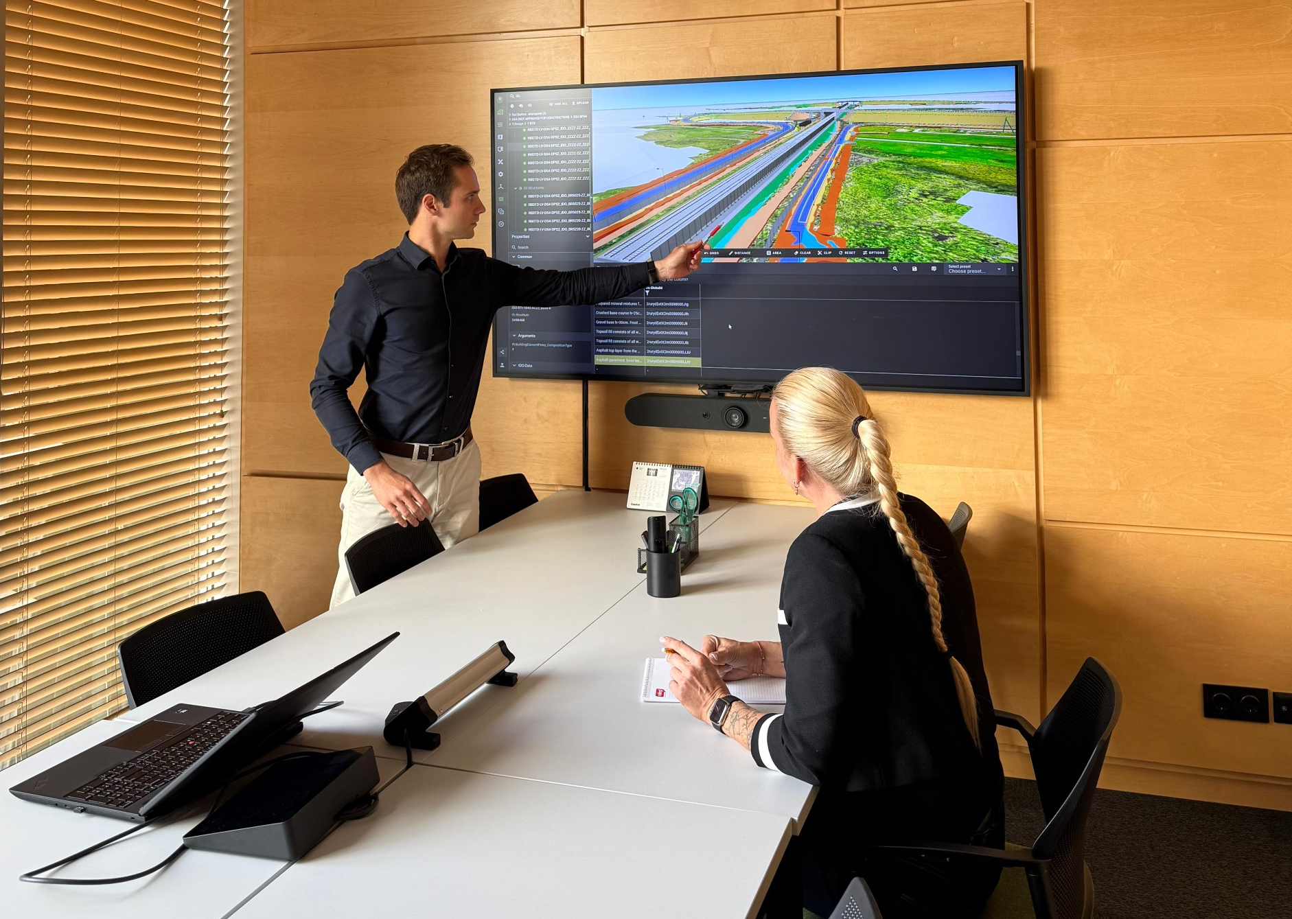
In this context, Vektor.io has served as a practical tool in the Airport Line project for reviewing design data, supporting stakeholder interaction, and visualizing plans.
A large rail project generates extensive data and multiple alternatives
In long-term infrastructure projects, plans do not emerge fully formed at once. Different phases involve comparing multiple alignment options, refining solutions, and coordinating data from various disciplines into a unified whole.
According to Koski, this has meant a large volume of design data and multiple alternative solutions in the Airport Line project. Managing this requires a clear structure and easy-to-use tools. As versions and alternatives increase, finding the right data and understanding the overall situation becomes increasingly important.
Why Vektor.io was selected for the Airport Line project
The Airport Line project required an effective way to manage and review large volumes of design data and to make them easier to use for different stakeholders.
Vektor.io was introduced to address this need. According to Koski, one of the key benefits has been the ability to review data without separate design software. This has made work easier especially for the client organization and in situations where plans need to be reviewed with different stakeholders.
M-Files–Vektor.io integration as part of project information management
Document management in the Airport Line project is handled with M-Files, which serves as the project’s centralized Common Data Environment (CDE). M-Files is responsible for document structure, metadata-based classification, discoverability, and controlled storage.
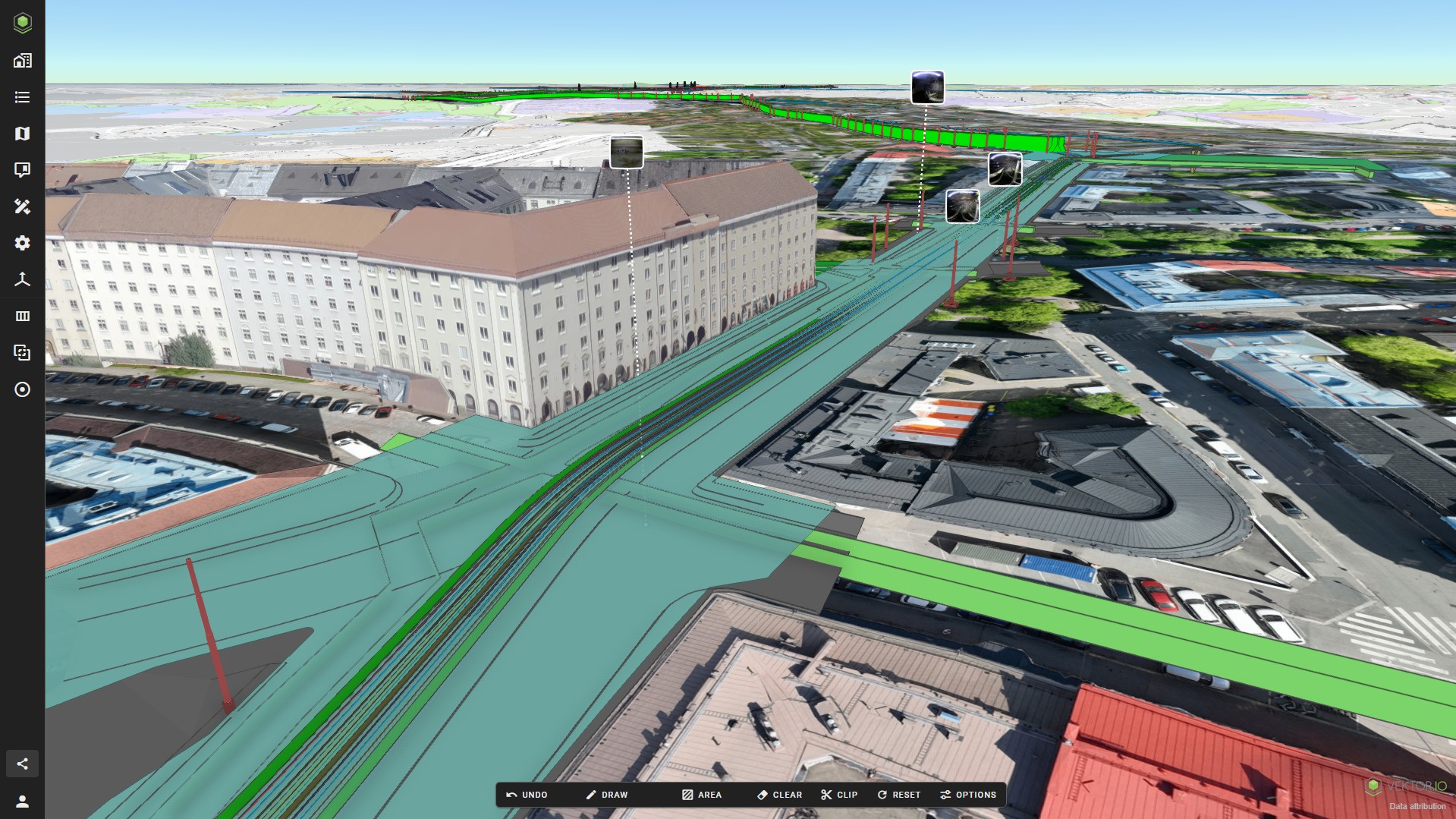
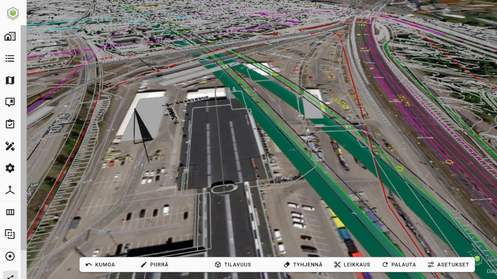
Vektor.io integrates with M-Files and utilizes its metadata structure to bring design data into a visual and accessible format. In practice, this means that the data viewed in Vektor.io is based on the same controlled and up-to-date information used across the project.
Designers and project management can review track geometry, models, and other design materials without separate file transfers or duplicate data management. At the same time, using up-to-date information becomes easier in situations where a quick overall view is needed.
Practical benefits in daily work
The value of Vektor.io is particularly visible in day-to-day work within the Airport Line project. Design data can be easily navigated, zoomed, and reviewed in combination with different source materials.
When data can be reviewed in a single view without heavy software or separate screenshots, discussions become more efficient and understanding improves.
Browser-based access also simplifies the work of the client organization, as reviewing plans does not require separate design software, licenses, or training.
The tool has also served as an important discussion aid in regular project meetings and in preparing alternatives for further processing.
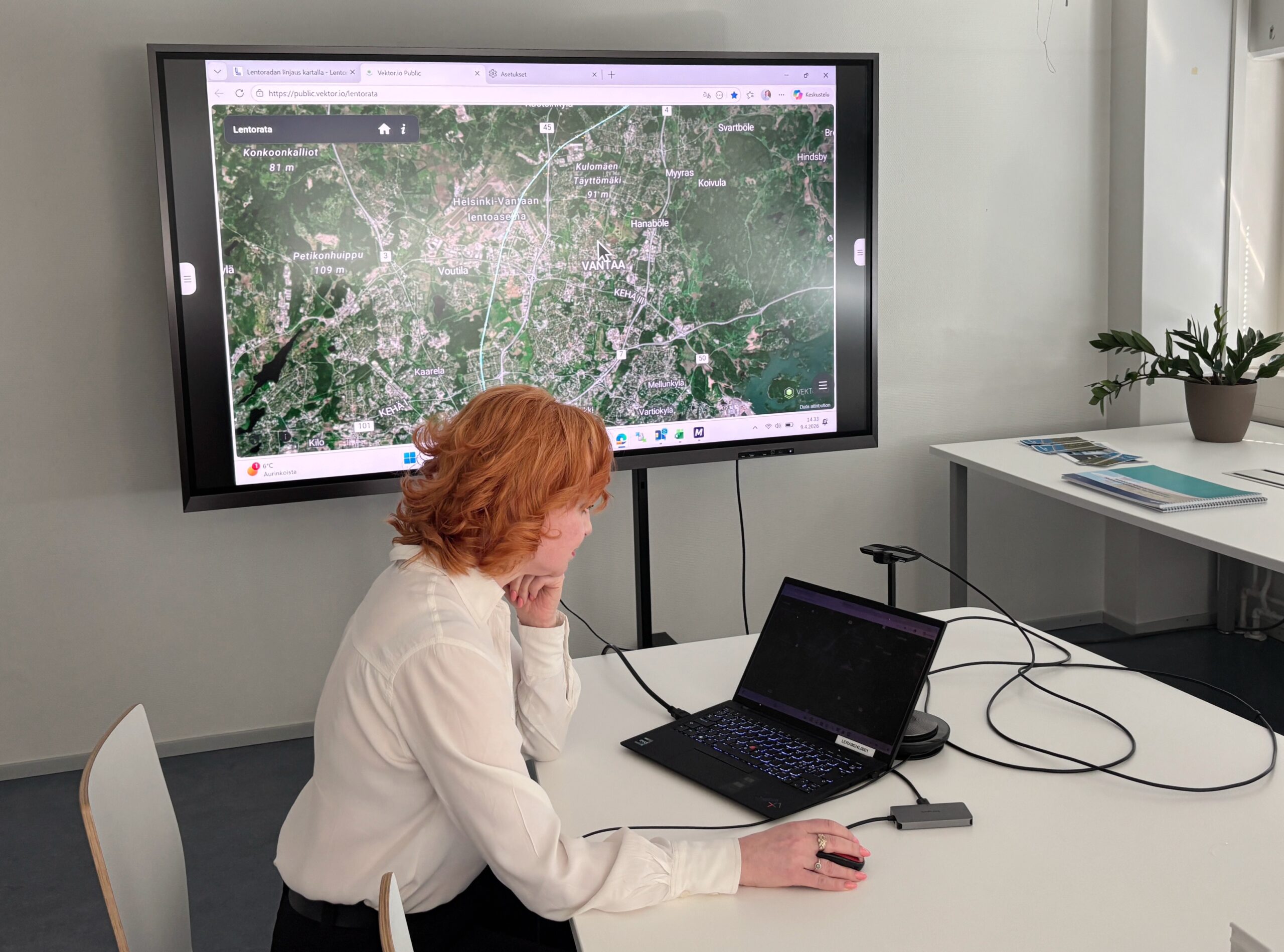
Vektor.io Public supports interaction with stakeholders and the public
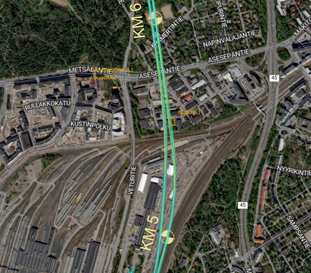
One of the most concrete benefits has been the Vektor.io Public map service, which has enabled plans to be clearly presented to external stakeholders. Representatives of municipalities and residents have also been able to review the rail alignment through an interactive map.
According to Koski, one of the most useful features has been the ability to locate feedback directly on the map and quickly understand how it relates to a specific location — for example, whether a tunnel, shaft, or other structure is planned nearby.
This has improved interaction and made it easier to respond to questions in a case-specific and understandable way, based on accurate location data. When feedback is linked directly to a location, resolving the matter is significantly faster compared to identifying the location from a separate message.
“I have mostly used this to answer people’s questions about what is happening in their area.”
– Siru Koski, Design Director, Airport Line Ltd
You can explore the public map service here: public.vektor.io/lentorata
Collaboration with Vektor.io is important in a long-term project
In a long-term project, requirements evolve over time. Therefore, in addition to the technical solution, the way collaboration with the software provider works in practice is also important.
According to Koski, key strengths in the collaboration with Vektor.io have been fast response times, openness to development ideas, and flexible support. New needs have been addressed quickly without heavy development processes.
“When we have explained what would improve usability or make work easier, the ideas have been received and taken forward.”
– Siru Koski, Design Director, Airport Line Ltd
Key benefits
- A clearer way to manage and review large volumes of design data
- Easier comparison of alternatives and better overall understanding
- Improved interaction with residents, municipalities, and landowners
- Seamless integration of information management and visualization
- Browser-based access reduces the need for separate design software
- Flexible collaboration and continuous development during the project
Frequently asked questions
Why is a browser-based solution useful in a rail project?
It makes design data easier to use without heavy software and improves accessibility for different user groups.
What was the role of M-Files in the project?
M-Files served as the project’s information management system, where documents, metadata, and classification were managed centrally. Vektor.io complemented this by providing a visual way to review the data.
How did Vektor.io support stakeholder interaction in the Airport Line project?
Through the Vektor.io Public map service, feedback could be linked to specific locations and plans could be presented in an understandable way to non-technical stakeholders.
About the Airport Line project
- A new approximately 25 km rail connection from Pasila via the airport to Kerava
- The line runs almost entirely in a tunnel
- Provides direct long-distance train connections to the airport
- Increases rail capacity on the congested Pasila–Kerava section
- Improves accessibility, reliability of rail services, and sustainable mobility
- The project progresses in phases toward implementation, with operations targeted to begin in the mid-2030s