
Cut and Fill Volume calculation – Now Accessible to the Whole Project Team, Right in the Browser
25.06.2025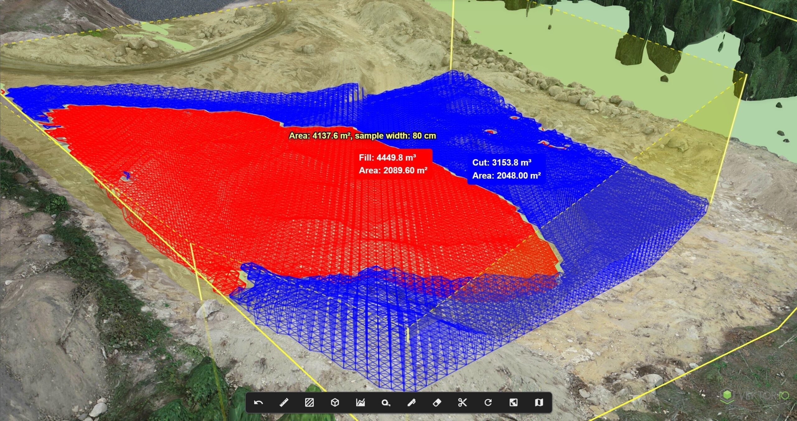
We’ve released a new Cut & Fill Volume Calculation tool in Vektor.io – a fast, intuitive, and visual way to compare earthworks surfaces and calculate volumes. This new feature improves how construction teams plan, track, and communicate earthwork progress – directly in the browser, without the need for heavy desktop software or specialist tools.
Calculate Volumes Between Different Data Types – Quickly and Easily
With the new tool, users can calculate earthwork volumes between:
- Cut volumes, fill volumes, and net totals between two surface layers – based on XML surface models or IFC-based geometries (e.g., existing terrain vs. design)
- Volumes between model-based surfaces (XML/IFC) and drone-derived data, where the comparison surface can be:
- A point cloud
- A 3D photogrammetry model
Calculations can be performed anywhere – no data transfers, no desktop software, and no need to wait for external analysis. Anyone on the project team – from site supervisors to quantity surveyors – can independently compare surfaces and make informed decisions.
Designed for Visual Clarity and Ease of Use
The interface is designed to be as simple and visual as possible:
- Select the surfaces directly from the project
- Get instant results as color-coded 3D volume maps (red = cut, blue = fill)
- See precise volume values without navigating complex menus
No CAD software or modeling skills required. Whether you’re on-site or in the office, you get the answers you need, when you need them.
Use Cases: From Planning to Progress Tracking
- Estimate cut and fill requirements during site preparation
- Compare design vs. as-built after drone flights or surveys
- Monitor earthworks progress over time using repeated drone captures
- Evaluate how design changes impact volumes directly in the field
- Quickly check how much material needs to be moved – and where
Developed With the Field in MindThis tool was built in collaboration with infrastructure professionals to solve a recurring challenge: understanding the difference between plan and reality – visually, quickly, and without friction. It supports Vektor.io’s broader mission: making model-based workflows truly accessible by bringing BIM-models, survey-, and drone data into a single browser-based platform.IM, drone, and survey data accessible in one intuitive platform.
Interested?
Want to see how Cut & Fill calculation works in practice? Book a demo

Read more
News
29.1.2025
Destia and Vektor.io Strengthen Collaboration with Enterprise License Agreement
Vektor.io and Destia, part of the international Colas Group, have entered into an enterprise license…

News
9.10.2024
Vektor.io Selected as the Information Modeling Tool for the Turku Tramway Project
The Turku Tramway Alliance has made a significant decision by adopting the Vektor.io software service…

News
17.10.2024
Meet the Team: Customer Success Manager Herkko Laine
Herkko Laine works in Vektor.io’s customer team, excelling in his role as Customer Success Manager…